20/11/2018-26/11/2018
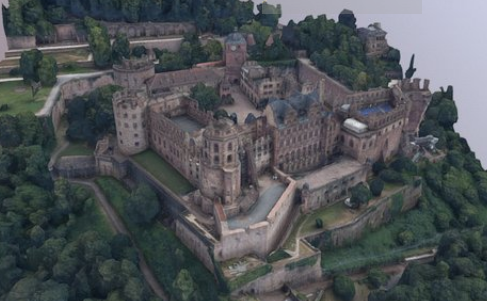
3D model of the Heidelberg Castle, one of the most famous ruins in Germany 1 | © Landesamt für Denkmalpflege im Regierungspräsidium Stuttgart 2018
Mapping
- John Whelan shares his view about the project Building Canada 2020 and how to proceed with mapping buildings. The release of government data and the expectation that Microsoft will release building footprints as they did for the US makes him conclude that the addition of metadata might be better than having inexperienced mappers tracing buildings using iD.
- A proposal
 (automatic translation) has emerged from the discussion in the German forum about rules for the use of relations with
 type=multipolygon. The intention of the proposal is, simply said, the avoidance of multipolygon relations if the geometry can be mapped with a single way representing the area, i.e. no inner areas and less than 2000 nodes for the area’s outer way. The topic is currently being discussed on the German forum (automatic translation ) and German mailing list (automatic translation) and is intended to be a guide to best practice for Germany initially. - The voting on the tagging proposal
boundary=aboriginal_landsfor the official territories of indigenous groups has started eight years after its drafting and is open until 8th December 2018. Alan McConchie created a GitHub issue for the OSM Carto map style as well and proposes a rendering with a brown outline colour. - Warin felt that the Wiki for antennas needed some rework to allow a better specification of the antenna type. As he is confused by the values of the key
antenna:typein the German part of the wiki and he also does not favour that particular key, he is looking for alternative options.
 (automatic
 Community
- InfosReseaux wrote a post on his OSM diary about the mapping of infrastructure like power networks.
The article describes how infrastructure knowledge is changing from proprietary to open knowledge with OSM and how infrastructure mapping makes OSM better. - If you have recently used Pascal Neis’ How Did You Contribute website, you may have noticed a new section called Recently utilized presets – Top 3. In a blog post Pascal explains that it is intended as a new quality indicator.
OpenStreetMap Foundation
The recent DWG decision on the Crimean peninsula has provoked many discussions:
- a summary in Russian language in Zverik’s OSM-Blog (automatic translation)
- A discussion in the Ukrainian OSM-Forum (partly English, partly Ukrainian) (automatic translation)
- A discussion on the talk mailing list started by a post criticising the decision.
- Several OSM diary entries by Ukrainian mappers objecting to the decision including this one and this one by Kilkenni (with many comments, including some objecting to the ad-hominem attacks it contains).
- Over on reddit
- Multiple people have suggested how to map disputed and claimed territories on the Talk and Tagging (1, 2) mailing lists. (proposal by johnparis, proposal by Rory). It was also discussed whether it made sense to store such claims in OSM at all.
- Someone has sent a formal complaint to the OSMF board of directors.
- a summary in Russian language in Zverik’s OSM-Blog
- The OSMF board informed the members that it has declined a request to reject the membership application requests related to a "mass sign-up of 100 new accounts on 15 Nov 2018 from India, most coming from one single IP address from a company ‘well known’ to OpenStreetMap". The new members are not eligible to vote this year. However, the decision was followed by a long discussion on the mailing list.
- Joost Schouppe, candidate for this year’s OSMF board election, analysed the OSMF membership per country in total and relative to the numbers of contributors.
- The minutes of the Data Working Group meetings of 10 July, 13 September and 15 November have been published in the foundation’s "working group minutes" area.
 (automatic
 Humanitarian OSM
- The Erasmus + European Youth Humanitarian OpenStreetMap (euYoutH_OSM) Students announced in a tweet that on November 23th, some ESJEA teachers began their training in OpenStreetMap in a session guided by teachers Nuno Azevedo and Elizabete Oliveira. Teachers worked with JOSM putting Terceira Island more and more on the map. euYoutH_OSM announced on November 26th, the Sports Technician course had the opportunity to receive training in JOSM. The graduates of this course have learned how to design buildings, properties and to label structures yet to be mapped.
- HOT and Kathmandu Living Labs will cooperate with the mapping of Kathmandu, the capital of Nepal. KLL will map buildings remotely before information will be gathered on the ground to complete the assessment. The results will be used to validate the data sets for Nepal that show the exposure of a region to natural hazards.
- Three data science students are asking for "validated regions" for a machine learning project. The plan is to download a dataset to train and test automated mapping models using the satellite images.
Education
- The Data Wrangling part of Udacity’s Data Analyst course uses Openstreetmap as a project. Students are introduced to OSM and the data model and have to export, filter and analyze a large area from OSM.
Maps
- Ingress agent Hinata Kino published a real-life locations map for the ingress anime. He mapped the place where the event happened with anime using a map based on OSM.
- Wikipedia user Triglav wrote about a way to embed OSM on wikipedia pages. You can combine OSM relations with Wikidata and highlight it with Wikipedia.
 a real-life locations map for the ingress anime. He
 Software
- Cadcorp, a British provider of GIS services, to local authorities in particular, have updated their software and now it includes an OSM layer.
- An alpha version of Atlasr, an open-source map browser, has been released. Atlasr consists of modules like a map data database, a map renderer, a tile server, a geocoder and routing. It aims to offer a smooth, fast, reliable, pretty, and open source alternative to GoogleMaps, based on open data,. The software is available on GitHub.
Programming
- Matthias(OSM username !i!) experimented with speech recognition and connected it to JOSM – speech2josm. The prototype is written in Python. Matthias wants to find someone who can create this as a new JOSM plugin. He writes more in his blog post. (automatic translation)
Releases
- Version 4.17.0 of the OSM’S Carto stylesheet has been released. As Daniel Koć writes in his blog, the changes include an earlier rendering of natural areas, clean up of medium zoom rendering, as well as new rendering and new icons for several features.
- Heidelberg University’s GIScience Research Group has published version 3.2 of its QGIS OSM Tools Plugin. It now includes access to the routing functions of openrouteservice.org.
- QGIS 3.4 ‘Madeira’ has recently been released. This version is the first long term release for version 3. The new version includes a ton of new features in the very long changelog.
Did you know …
- … the highly detailed map of Bexhill-on-Sea in England, created using OpenStreetMap? And now with a topical issue. Highly recommended for all organisations active in tourism.
OSM in the media
- The Deccan Chronicle reports about an event, hosted at the Indian Institute of Management-Bangalore, where over 300 mappers from 12 countries discussed disaster mapping related topics like the importance of disaster mapping, the role languages play in tagging places, community building and many other.
- The website The Better India is proposing its readers pick up a new hobby: OSM. The short article covers some basics about OSM, what OSM can do for the civil society and mentions the recent State of the Map in India.
Other “geo” things
- The Open Data Institute (ODI) calls on the government to break the dominance of commercial online giants of the UK’s geospatial data by moving the business model of public bodies more towards open data and thinking about mandating access to the geospatial data of private companies. A broad, public debate should discuss the role of public and private organisations in the context of geospatial data.
- Municipal Dreams tweets a photo of an old map of London’s main sewage system.
- The German state Baden-Württemberg has released many 3D models of historic castles, palaces and monasteries under a proprietary license. The repository Sketchfab holds a directory for the, so far non-downloadable, 3D models. The only other disadvantage is that Neuschwanstein Castle is in Bavaria.
- Paul Ramsey blogged about the response by an ESRI sales representative when Paul spoke to a local GIS user group about the risks of being tied to a single software vendor. (via @anonymaps)
Upcoming Events
| Where | What | When | Country |
|---|---|---|---|
| Alice | PoliMappers Adventures 2018: One mapping quest each day | 2018-12-01-2018-12-31 |  |
| Toronto | Mappy Hour | 2018-12-03 |  |
| Niamey | OSM and GIS training camp at CNF | 2018-12-03-2018-12-07 |  |
| London | London Missing Maps Mapathon | 2018-12-04 |  |
| Viersen | OSM Stammtisch Viersen | 2018-12-04 |  |
| Praha – Brno – Ostrava | Kvartální pivo | 2018-12-05 |  |
| Stuttgart | Stuttgarter Stammtisch | 2018-12-05 | |
| Toulouse | Rencontre mensuelle | 2018-12-05 |  |
| Bochum | Mappertreffen | 2018-12-06 | |
| Dresden | Stammtisch Dresden | 2018-12-06 | |
| Nantes | Réunion mensuelle | 2018-12-06 | |
| Tångstad | Foundation board elections voting opens | 2018-12-08 | – |
| Rennes | Réunion mensuelle | 2018-12-10 | |
| Lyon | Rencontre mensuelle pour tous | 2018-12-11 | |
| Zurich | Jubilee Stammtisch Zurich with Fondue | 2018-12-11 |  |
| Salzburg | Maptime Salzburg | 2018-12-12 |  |
| Helsinki | Missing Maps Mapathon at Finnish Red Cross HQ – Dec 2018 | 2018-12-13 |  |
| Munich | Münchner Stammtisch | 2018-12-13 | |
| Berlin | 126. Berlin-Brandenburg Stammtisch | 2018-12-14 | |
| online via IRC | Foundation Annual General Meeting | 2018-12-15 | |
| Cologne Bonn Airport | Bonner Stammtisch | 2018-12-18 | |
| Lüneburg | Lüneburger Mappertreffen | 2018-12-18 | |
| Nottingham | Pub Meetup | 2018-12-18 | |
| Reutti | Stammtisch Ulmer Alb | 2018-12-18 | |
| Rennes | Recensement des panneaux publicitaires | 2018-12-23 | |
| Heidelberg | State of the Map 2019 (international conference) | 2019-09-21-2019-09-23 | |
Note: If you like to see your event here, please put it into the calendar. Only data which is there, will appear in weeklyOSM. Please check your event in our public calendar preview and correct it, where appropriate.
This weeklyOSM was produced by Nakaner, NunoMASAzevedo, Polyglot, Rogehm, SK53, SomeoneElse, SunCobalt, TheSwavu, YoViajo, derFred, jinalfoflia, k_zoar, muramototomoya.