03/01/2016-03/07/2016
 Map-Matchings from Barefoot [1] | © Mapbox © OpenStreetMap Improve this map © DigitalGlobe © geojson.io
About us
- We are sad to inform everyone about the loss of our very dedicated member of the weeklyOSM team, Dr. Bogus Zaba aka bogzab. He passed away this week after a short illness. He will always remain in thoughts and we’ll always remember him for his contribution and dedication towards weeklyOSM and OpenStreetMap. We’ve lost a friend. Adieu Bogus, Jinal from Bangalore. Es una pena perder un miembro tan valioso, un saludo de Laura de La Habana de Cuba.
Mapping
- In an article in geops.de, the authors of TRAVIC discuss why there are differences in traffic routes between TRAVIC and reality. The authors encourage users to help improve the routing by correcting the routes in OSM, adding transportation vehicles types (bus, tram, etc) and names.
- Many mappers who used the new JOSM 9900 had problems with the OAuth certification. Solution in JOSM:
- Edit -> Preferences, Connection Settings (Second Icon from top – looks like a globe).
- Go to the Authentication tab (oAuth) -> New Access Token
- Choose from the dropdown menu -> Semi-automatic
- Select Retrieve Request Token (a new browser window will open, select
grant access.) and then again select Retrieve Access Token -> Accept Access Token. (Video)
The upcoming release from 10. 03. should remove the OAuth problem. UPDATE: the new 9963 should be free of OAuth problems. The .jnlp-file starts already the version 9979.
- Matthijs Melissen reports that
office=governmenttag has been approved. The proposal also suggests marking the alternatives tagsamenity=public_buildingandoffice=administrativeas ‘discouraged’. - On the OpenRailwayMap mailing list Alexander Matheisen proposes a tag to map the importance of train stations. This is based on a proposal by user Skunk from 2009 modified to be more useable in large countries (e.g. USA).
- User Rub21 writes his diary post on how to use OSMLint to detect errors in OpenStreetMap based on vector data tiles.
- TIGER data (which had been imported to OSM) often shows questionable quality and accuracy.
- Users Warin has made a proposal to tag the product ranges of POIs on the tagging mailing list, but this has been criticised on several points. The developers of iD and Vespucci are bothered by the use of an unlimited number of keys. Frederik Ramm speculates about importing a supermarket’s entire product list (and the dangers of inviting this). He points out that OSM is not a business directory and is not the right place to map ontologies.
- The UK Quarterly Projects is supported by MapRoulette. (click Sign in → Pick another Challenge, then scroll down and select UK schools). Additionally, the UK mapped the most number of new schools in one day, on the 2nd of March.
- user bjoern262 is asking in the OSM Forum for help on how to effectively map diversions in public transportation routes so that they can be “deleted” easily.
Community
- A chat with Stephane Branquart about OpenStreetMap in Morocco.
- MarkusHD published a Greasemonkey script that helps to keep an overview of comments on diary entries.
OpenStreetMap Foundation
- The annual general meeting of SOSM (Swiss OpenStreetMap Association) will take place on the 2nd of April. One point of the agenda will be the to vote for SOSM to become an official Local Chapter.
Events
- A talk about making large heterogeneous datasets available will be presented at the theme day “Geoinformation / Geodesy / Land Management / Cartography” at the CeBIT 2016 fair.
- The call for venues for SotM 2017 is now open!
- The State of the Map US 2016 will take place in Seattle, Washington, from July 23rd to 25th. More regional SotM conferences can be found on the OSM blog.
Humanitarian OSM
- The discussion regarding the new Missing Maps website continues.
- HOT in Indonesia is planning for University engagement and partnership to utilise OpenStreetMap data for disaster risk management.
- Marc Farra published the live leaderboard of the Missing Maps users.
Maps
- Though there are no user visible changes, the OpenSnowMap was rewritten from scratch to have a cleaner codebase. They have also asked the users to make feature requests and report bugs.
- The “Alianza Libres Sin Violencia” (Free Alliance without violence) is an association of 50 organizations in Bolivia which opposes violence against women. In this map you can find contacts for psychological counselling centres, police and state institutions to which women can apply.
- In Mapzen’s company blog you can read about the new features of Mapzen’s vector tile service. Feedback is appreciated.
- The OpenLinkMap returns again for the second time. (As reported in “German Wochennotiz” issue 73 and 286)
switch2OSM
- A platform exists which can tell you how long it would take for civilisation to collapse if you were patient zero in a catastrophic smallpox outbreak. It is based on data from OpenStreetMap and IATA flight routes. The creatives were Vincent Blachere, Raphael Perrollier, Adrien Héron, Alban Gallée and Simon Lamasa.
Open Data
- Australia switches its national address database G-NAF releasing 13 million records under Open Data. The records are available at data.gov.au.
- Initial reports from the International Open Data Day 2016:
- Mappillary worldwide.
- “We were on the Open Data Day Münster” (Freifunk Community)
Software
- The new 2.3 version of OsmAnd has planned to add a new service called OSM Live. However, this is considered harmful by many, not only because of missing OAuth.
Programming
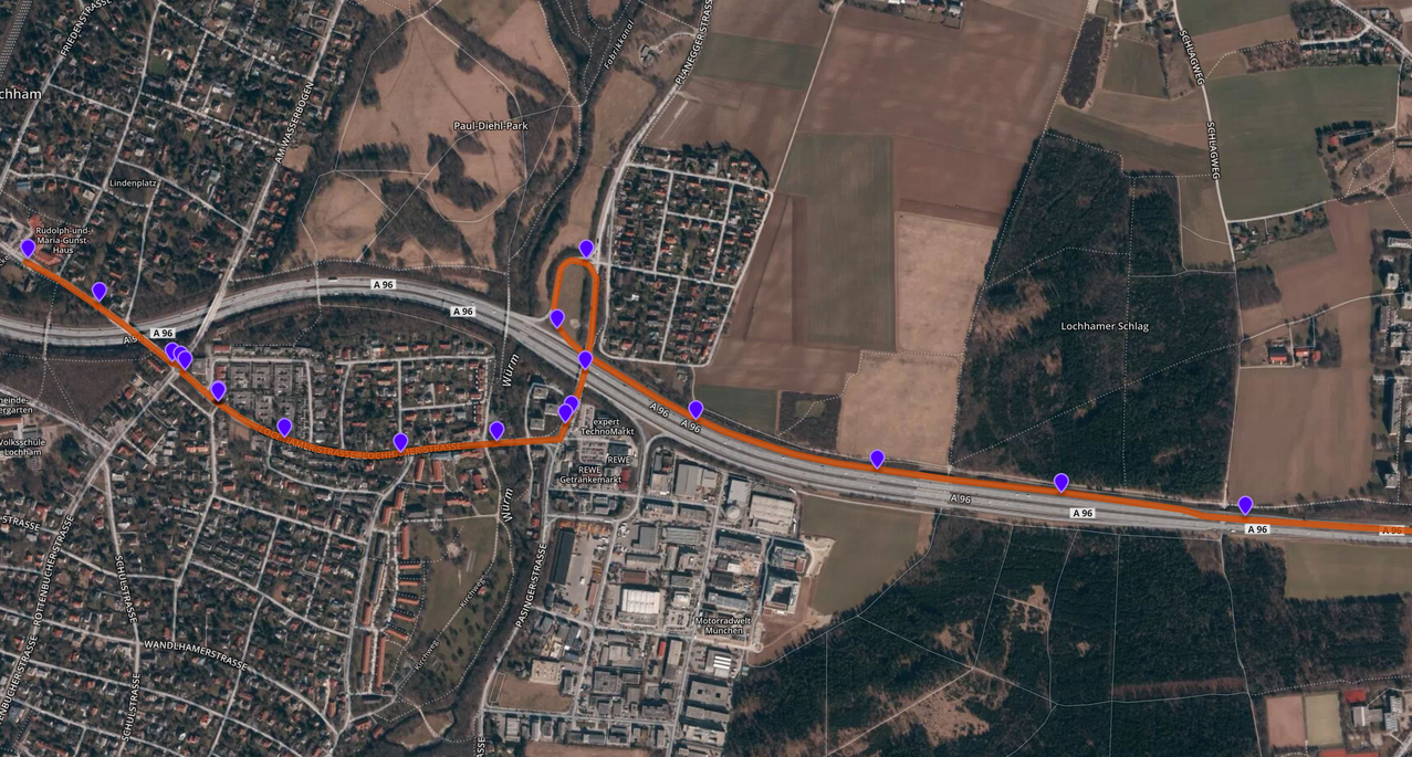
- [1] BMW Car IT published the Java library Barefoot, allowing Offline and Online map matching on OpenStreetMap data.
- After announcing the new Raspberry Pi 3 user mmd pointed out on the Overpass mailing list on his experiments with the Raspberry Pi 2 and he searches for applications in which a Raspberry Pi could be useful with a Overpass API.
Releases
| Software | Version | Release Date | Comment |
|---|---|---|---|
| OpenLayers | 3.14.2 | 2016-02-03 | Some patches of 3.14.1 |
| QGIS | 2.14.0 | 2016-02-26 | LTS release |
| Mapillary for iOs | 4.1.4 | 2016-03-01 | Removed memory problems, action cam errors fixed |
| Maps.me Android | 5.6.5 | 2016-03-02 | – |
| OpenStreetMap Carto Style | 2.39 | 2016-03-02 | – |
| osm2pgsql | 0.90.0 | 2016-03-02 | Many changes for windows, integration of LibOsmium |
| OSMBuildings | 2.3.1 | 2016-03-02 | Bug fix release |
| iD | 1.9.1 | 2016-03-03 | Bug fixes of version 1.9.0 from 2016-03-01 |
| SQLite | 3.11.1 | 2016-03-03 | Some improvements and bug fixes |
provided by the OSM Software Watchlist
Other “geo” things
- A book from Gretchen Peterson and Anita Graser titled: “QGis Map Design“. The subtitle “Take Map Design to the Next Level with QGIS” is promising. The Price is 40.10 €uro, £27.99 in the UK and $33.72 in the US or ₹ 3,109.00 in India.
- The next version of Google Maps tries to predict your next destination.
- Emily explains isodistances, the points on a map that all are reachable after the same driven distance.
- GeoHipster publishes an interview with Jan Erik Solem, the CEO and co-founder of Mapillary.
- Mapillary closed a further financing round, getting access to 8 million US Dollars for further expansion.
- Mozilla Foundation writes about their future being the internet of things.
Upcoming Events
| Dónde | Qué | Fecha | País |
|---|---|---|---|
| Wyoming | Humanitarian Mapathon University of Wyoming, Laramie | 09/03/2016 |  |
| Bogota | Mapping party – Bogota: Lourdes | 12/03/2016 |  |
| Kyoto | 京都世界遺産マッピングパーティ:第12回 特別編 延暦寺 | 12/03/2016 |  |
| Moscow | Schemotechnica 02 | 15/03/2016 |  |
| Brussels | Missing Maps Mapathon | 16/03/2016 |  |
| Chemnitz | Chemnitzer Linux-Tage 2016 | 19/03/2016-20/03/2016 |  |
| Akihabara | 第2回秋葉原マッピングパーティー | 20/03/2016 | |
| Nottingham | Nottingham | 22/03/2016 |  |
| Antwerp | Missing Maps Mapathon | 23/03/2016 | |
| Rennes | Rencontres mensuelles | 23/03/2016 |  |
Note: If you like to see your event here, please put it into the calendar. Only data which is there, will appear in weeklyOSM. Please don’t forget to mention the city and the country in the calendar.
This weekly was produced by Harry Wood, Nakaner, Peda, Rogehm, derFred, jinalfoflia, mgehling, seumas, stephan75, wambacher, widedangel.