OSM Mingguan 844
We are looking for volunteers to help us translate! Please get in touch with us: info@weeklyOSM.eu
17/09/2026-23/09/2026
About us
- Next week we will launch our completely revamped website; an exciting milestone for us! With Hugo as our new framework, a self-hosted commenting system (Remark42), and our own Listmonk server for managing mailing lists, we’ve modernised our publishing workflow and automated key processes. The source code is available, along with the complete archive in Markdown format, in the FOSSGIS GitLab repository. Cross your fingers for a smooth transition.
Mapping campaigns
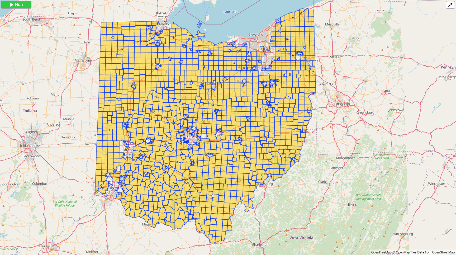
- [1] After almost 15 years, mappers in the US state of Ohio have finished mapping the boundaries of all 1,309 townships there. The community overcame a lack of accurate, authoritative, external datasets by reconciling a variety of sources. Work remains to clean up and update municipal boundaries, which often influence township boundaries.
Community
Walid Nouh has interviewed members of the OpenStreetMap France board on the Projets Libres podcast. The episode’s guests were asked to talk about OSM-FR, who they are, what the association does, and its current activities.
Because there were three votes against the Lgbtq=* proposal without a reason being provided (see the discussion on the OSM Community forum about it), Spughetti, the author of the proposal, has written a proposal to introduce a strict requirement to provide a valid reason to vote against a proposal. The reactions on some posts show a split in the community. This is not a good sign for a proposal required to pass the 75% requirement in the voting phase.
Imports
- Imports of boundary and cadastral datasets in Belgium and France have more than doubled the size of OpenHistoricalMap since the beginning of August. The new data skews OHM more heavily toward recent decades but gives contributors more opportunities to improve historical coverage based on present-day features.
OpenStreetMap Foundation
- The OpenStreetMap Foundation is inviting you to its 20th Annual General Meeting, being held on Saturday 17 October 2026 at 16:00 UTC. The meeting will take place online. The agenda includes apologies for absences, the minutes of the previous Annual General Meeting, reports from the Chair, the Treasurer and the Personnel Committee, the election of the Board, and any other business.
Events
- At the 2026 Ukrainian Urban Forum ‘After Nature’, held in Cherkasy, a dedicated discussion focused on GIS and crowdsourced geospatial data for communities. Fedir Gontsa, a member of the Ukrainian OpenStreetMap community, spoke about the project and showed how micromapping can help cities collect data on accessibility, green spaces, and other features of the urban environment.
Maps
OsmAnd has published an experimental heatmap similar to Strava Heatmaps but based on GPX traces uploaded by mappers to the OSM API.
Roni Lindholm made wayside.cc, an OpenStreetMap-powered web map that displays small points of interest that are hard to find elsewhere, such as public toilets, drinking water, playgrounds, post boxes, luggage lockers, shelters and more.
Wynndale has argued in favour of moving OSM away from the Mercator projection, as modern processors have long been capable of rendering vector tiles in any projection. Mercator not only distorts sizes, but also causes the scale to vary between zoom levels depending on latitude, and creates a gap around 1,000 km wide at both poles. As alternatives, he suggests geographical coordinates with cosine scaling for large-scale maps, as well as area-preserving projections such as Equal Earth, and further illustrated the principle using an orthographic globe view.
OSM in action
Der Spiegel used OpenStreetMap as its map base to display election results in Berlin’s individual constituencies.
Geht-Doch Wien, Walk-Space, and Radlobby created ► a map to visualise potential locations for public seating in Vienna, based on OpenStreetMap data. This map shows how seating at regular intervals can support independent mobility for people with mobility impairments, with seating every 100 metres recommended for an inclusive and barrier-free city.
The United Nations Economic Commission for Europe (UNECE) maintains UN/LOCODE (United Nations Code for Trade and Transport Locations), a global UN/CEFACT standard for codes relating to trade and transport locations, which is freely available under a CC BY 4.0 licence. The codes can be searched via the online directory, and the list is also available as a SKOS vocabulary in Turtle format. Interested parties can submit requests for changes and new entries via a Data Maintenance Request. The maintenance team decides on these requests at regular meetings, which are open to the public. The new platform uses OpenStreetMap to display the registered coordinates and Nominatim for search.
Software
Chris Debian reported that Mapilio Mobile, a mobile app for turning photos into street-level imagery and map data, is now open source.
Sanjay Bhangar has noted that osm-seed moved out of the Development Seed GitHub org and into its own home at github.com/osm-seed. The change reflects how the project is actually being used and maintained today.
Peter has built a
maxheighteditor that makes contributingmaxheightdata more interesting as it calculates the chance of an important bridge-related restriction. The editor also makes it also easier for armchair mappers as it displays Mapillary signs and street images from various open services.HeiGIT released two analysis tools based on shadow data to support active mobility during summer months. The hiShade plugin in the Climate Action Navigator shows how shade is distributed across a neighbourhood. The shadow routing application calculates pedestrian routes that keep people out of the sun.
Programming
Timothé Baleras, Martin Constantino-Bodin, and Ugo Comignani developed Cosmetyc, a library for manipulating OpenStreetMap data in OCaml. The development of this library led to an article, presented at the 37th Francophone Conference on Applied Languages.
Jesse Back said on LinkedIn that he cold emailed 1,000+ German farmers by using satellite data to estimate how many hectares of land they work. You can watch the video on YouTube, where he explains his workflow in more detail, which includes OpenStreetMap and Overpass API.
Did you know that …
- … map projections seem to be having a moment? Tobias Jung has a website where you can view 355 different projections and compare between them. You can also read Tobias’ 2018 review of the Equal Earth projection.
OSM in the media
- Heise has published a YouTube video about OSM-based alternatives to Google Maps.
Other “geo” things
Ben Joffe has developed an equal-area projection that uses simple closed-form functions in the forward and inverse directions. By adjusting parameters a map can seamlessly transition to Mercator when zooming in. The method also can be used as a new compromise cylindrical projection that also transitions to Mercator when zooming in.
Pinlyx has analysed the Turkish website data from the Overture Maps Foundation Places dataset, which contains no OpenStreetMap data, to check how many business websites remain accessible. Their analysis found that of the 685,343 Turkish business websites listed, 271,566 websites did not respond, and 164,281 no longer resolved to anything.
London Centric reported how drug dealers in London are using Google Maps to advertise themselves by hijacking searches for pharmacies.
Sebastian Gräff, from The European Correspondent, has published a map that shows where the concert genres of Europe perform (excluding ‘pop’) and asked the reader ‘Europe hosts over 125,000 concerts a year. Who’s playing where?’.
Yandex.Maps has started embedding ads in its free map widgets that are used on many sites. In the comments, there was discussion of alternatives, including self-hosting using OSM. However, some users noted that most of the alternatives require technical training and reading documentation, which is quite difficult for owners of small websites.
Upcoming Events
| Country | Where | Venue | What | When |
|---|---|---|---|---|
| 🇮🇳 | Bengaluru | NIMHANS Convention Center | OSM India @ IndiaFOSS 2026  | 2026-09-25 - 2026-09-27 |
| UN Mappers Mappy Hour | 2026-09-25 | |||
| 🇲🇽 | Torreón | Universidad Tecnológica de Torreón | Conferencia “OpenStreetMap: Datos abiertos y más” | 2026-09-25 |
| 🇲🇽 | Torreón | Universidad Tecnológica de Torreón | Taller “Mapeando mi entorno” | 2026-09-25 |
| 🇩🇪 | Düsseldorf | Online bei https://meet.jit.si/OSM-DUS-2026 | Düsseldorfer OpenStreetMap-Treffen (online) | 2026-09-25 |
| 🇩🇪 | Karlsruhe | Geofabrik, Amalienstraße 44, 76133 Karlsruhe | Karlsruhe Hack Weekend September 2026 | 2026-09-26 - 2026-09-27 |
| Kanjikode, Palakkad, Kerala | OSM Workshop SotM Kerala Pre-event -1 | 2026-09-26 | ||
| 🇫🇷 | Nantes | Le Wagon Nantes | OpenStreetMap, la balade de la data | 2026-09-26 |
| Sudan Solidarity Series | 2026-09-26 | |||
| 🇸🇪 | Uppsala | Datorföreningen Update | Mapping meetup in Uppsala | 2026-09-27 |
| CartONG : Mapathons en ligne 2026-2027 | 2026-09-28 | |||
| 🇫🇷 | Saint-Étienne | Zoomacom | Rencontre Saint-Étienne et sud Loire | 2026-09-28 |
| 🇩🇪 | Magdeburg | Netz39 e.V. , Leibnizstraße 32, 39104 Magdeburg | 4. OSM Stammtisch Magdeburg | 2026-09-29 |
| 🇺🇸 | Palo Alto | Startup Island Taiwan | South Bay Wiki and OpenStreetMap Meetup | 2026-09-29 |
| 🇩🇪 | Mannheim | RaumZeitLabor, Mannheim | Rhein-Neckar OSM Treffen | 2026-09-30 |
| Auburn Red Cross Missing Maps Mapathon | 2026-10-01 | |||
| 🇫🇷 | Angers | L’Arrière Train, 3 rue de Frémur, Angers | Angers Rencontre mensuelle OpenStreetMap | 2026-10-01 |
| 🇫🇷 | Bar Le Schmilblik | Rencontre mensuelle des contributeurs Paris sud | 2026-10-01 | |
| 🇮🇹 | Messina | Fablab Messina (via Croce Rossa 63, 98124 Messina) | Hackathon Wikimedia & OSM | 2026-10-02 - 2026-10-04 |
| 🇩🇪 | Essen | Linuxhotel Essen | FOSSGIS-OSM-Communitytreffen Nr. 26 im Linuxhotel | 2026-10-02 - 2026-10-04 |
| 🇪🇸 | Langreo | Casa de la Cultura “Escuelas Dorado” | GeoCamp 2026 | 2026-10-03 |
| 🇮🇳 | नई दिल्ली | Jitsi Meet (online) | OSM India - Monthly Online Mapathon | 2026-10-03 |
| 🇩🇪 | Essen | Verkehrs- und Umweltzentrum | Essen OSM-Treffen | 2026-10-03 |
| TNEI Mapathon 2026 | 2026-10-05 | |||
| 🇹🇼 | 臺北市 | MozSpace Taipei | OpenStreetMap x Wikidata Taipei #93 | 2026-10-05 |
| 🇨🇭 | Bern | SBB Headquarter | Open Transport Community Conference 2026 | 2026-10-06 - 2026-10-09 |
| 🇦🇹 | Salzburg | Bewohnerservice Elisabeth-Vorstadt | OSM-Treffpunkt | 2026-10-06 |
| 🇩🇪 | Braunschweig | Stratum 0 | Braunschweiger Mappertreffen im Stratum 0 Hackerspace | 2026-10-06 |
| Missing Maps London Mapathon Beginner Friendly (with Training) (Online) [eng] | 2026-10-06 | |||
| iD Community Chat | 2026-10-07 | |||
| Ghana | Everywhere She Maps workshop 2026 | 2026-10-07 - 2026-10-08 | ||
| Barricade, Liège | Carto party OpenStreetMap Café Crypté Liège | 2026-10-07 | ||
| 🇩🇪 | Stuttgart | Forum 3 Café | Stuttgarter OpenStreetMap-Treffen | 2026-10-07 |
| Barcelona | Junta d’OpenStreetMap Català | 2026-10-07 | ||
| Brighton College Bangkok Mapathon | Missing Maps Mapathon (Beginner) - Bangkok, Thailand | 2026-10-08 | ||
| Galerie Bortier | Brussels meetup - byebye Thierry & Joost | 2026-10-08 | ||
| 🇩🇪 | Bochum | Das Labor, Alleestraße 50, Bochum | OSM-Treffen Bochum | 2026-10-08 |
| irgendwo im Breitsch, wird noch definiert | OSM-Znacht in Bern | 2026-10-09 | ||
| 🇮🇹 | Catania | Biblioteche Riunite Civica e A. Ursino Recupero | Modifichiamo Wiki e OSM insieme! - Catania | 2026-10-10 |
| École Nationale Supérieure d’Arts et Métiers | OpenStreetMap, des cartes à la carte ! | 2026-10-10 | ||
| 🇩🇰 | København | Cafe Bevar’s | OSMmapperCPH | 2026-10-11 |
| École Nationale Supérieure d’Arts et Métiers | OpenStreetMap, des cartes à la carte ! | 2026-10-11 | ||
| 🇮🇳 | New Delhi | East Delhi | OSM Delhi Mapping Party No.33 (East Zone) | 2026-10-11 |
| Panoramax Nederland - Online Community Meeting #1 | 2026-10-12 | |||
| CartONG : Mapathons en ligne 2026-2027 | 2026-10-12 | |||
| 🇳🇱 | Amsterdam | TomTom HQ | 2026 Autumn Maptime | 2026-10-12 |
This weeklyOSM was produced by MatthiasMatthias, Nakaner, Raquel Dezidério Souto, Strubbl, Andrew Davidson, barefootstache, derFred.
We welcome link suggestions for the next issue via this form and look forward to your contributions.
Leave a reply