29/06/2021-05/07/2021
KGeoTag a standalone geotagging program for Linux [1] | © Tobias Leupold – KDE.org | map data © OpenStreetMap contributors
Mapping
- The Polish OSM community is proposing
 > an automated edit to update night-time urban speed limits.
 - The proposal to complement
man_made=utility_polewithutility=*, for poles that do not carry power or telecommunication lines, was approved with 16 votes for, 2 votes against, and no abstentions.
 >
> 
Community
- Apocolocyntōsis pondered where the pleasure of mapping comes from.
- DeBigC reviewed edits made in Ireland using StreetComplete over the past 5 years.
- laznik proposed sending invoices to companies employing mappers for our own community work. The post received many comments. He explains how the Rovas application could be used to create time reports, for which has also created a JOSM plugin.
- OpenStreetMap Belgium’s Mapper of the Month for July is Pieter (s8evq) from Belgium.
Imports
- User Michael proposes importing about 1000 fire hydrants around the town of Gangelt (Germany).
- Komadinovic Vanja announced the intention of the Serbian OSM community to import and update about 1500 post offices using data from the local postal service (JP Pošta Srbije).
- qeef wrote in his blog how the Tanga (Tanzania) building footprints import inspired him to present a mapping workflow to use with the data.
Events
- FOSS4G TOKAI 2021 will be held online on Saturday 28 August. You can apply now if you would like to present or otherwise participate.
- The Geomob podcast featured an interview with Gregory Marler about the State of the Map, which is taking place this weekend. Gregory is a member of the organising committee.
 will
will OSM research
- Using Robin Lovelace’s cyclestreets R package, Elise Desjardins and colleagues found that bicycle flows in Hamilton (Canada) correlate with shortest and quietest routes that minimise traffic.
Maps
- Using OpenStreetMap as a base layer, quitegrey has mapped the most efficient itineraries from Hornsey fire station (London) which could have been used for the rescue of 13 cats, from 13 different trees, since 2009.
- The OpenStreetMap Ops Team tweeted that there are new logs of frequently viewed tiles. They can be used for target mapping, pre-rendering, and more.
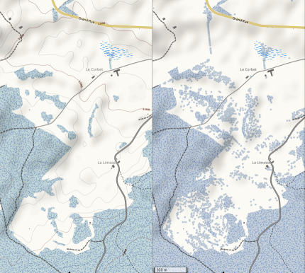
- yvecai has upgraded the style for OpenSnowMap. One thing it now includes is isolated trees (
natural=tree).
Software
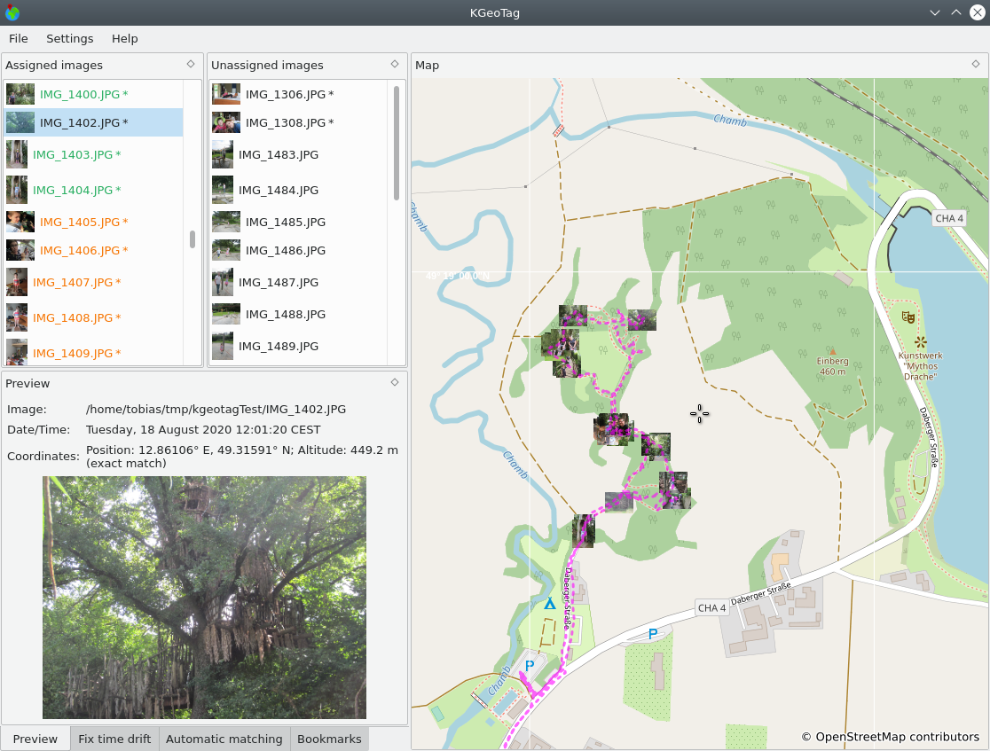
- KGeoTag is a new application in the KDE universe to map image files to GPS locations. This can help you to remember the exact location where a photo was taken or to discover other pictures taken at the same location.
- Tobias Zwick has built StreetCompleteness, a web interface showing the completion percentage for some chosen StreetComplete quests as a data quality analysis tool.
Programming
- Sarah Hoffmann gave an overview of how Nominatim handles abbreviations, such as St. in english (for Street or Saint).
Did you know …
- … the www.lightningmaps.org based on OSM?
- … OpenCage’s geothreads, notably those on geoweirdness, e.g., Norway or Italy?
- … OpenStreetMap Statistics – @OSMstats on Twitter?
OSM in the media
- Alex Hern of The Guardian reported on the OSMF’s intention to seek to relocate within the EU (as we reported).
- The Polish edition of PC Format invited > the OSMF to move to Poland.
Upcoming Events
| Where | What | Online | When | Country |
|---|---|---|---|---|
| OSM Africa Monthly Mapathon: Map Nigeria | 2021-07-02 – 2021-08-02 | |||
| State of the Map 2021 | 2021-07-09 – 2021-07-11 | |||
| Saint-Louis | Geomatica Mapathon: Réserve de Guembeul | 2021-07-10 – 2021-07-11 | sn | |
| Missing Maps Online Mapathon | 2021-07-12 | |||
| Hamburg | Hamburger Mappertreffen | 2021-07-13 |  | |
| OSM US Mappy Hour | 2021-07-15 | |||
| Albuquerque | MapABQ July virtual meetup | 2021-07-16 |  | |
| Missing Maps MSF-USA Virtual July Mapathon | 2021-07-16 | |||
| Bogotá Distrito Capital | Resolver notas de Bogotá creadas en OpenStreetMap | 2021-07-17 |  | |
| Derby | East Midlands OSM Pub Meet-up : Derby | 2021-07-20 |  | |
| Bonn | 141. Treffen des OSM-Stammtisches Bonn | ✓ | 2021-07-20 | |
| Berlin | OSM-Verkehrswende #25 (Online) | 2021-07-20 | | |
| Lüneburg | 2021-07-20 | | ||
| Lüneburg | Lüneburger Mappertreffen (online) | 2021-07-20 | | |
| Berlin | Missing Maps Ärzte ohne Grenzen Mapathon | 2021-07-21 | | |
| Virtueel treffen OpenStreetMap NL | 2021-07-24 | |||
| Bogotá Distrito Capital | Resolver notas de Bogotá creadas en OpenStreetMap | 2021-07-24 | | |
| Bremen | Bremer Mappertreffen (Online) | ✓ | 2021-07-26 | |
| Ville de Bruxelles – Stad Brussel | Virtual OpenStreetMap Belgium meeting | ✓ | 2021-07-27 |  |
| Aubière | Rencontre OpenStreetMap Clermont | 2021-07-28 |  | |
| Zürich | Missing Maps Zürich Mapathon | 2021-07-28 |  | |
| Düsseldorf | Düsseldorfer OSM-Treffen (online) | 2021-07-28 | | |
| [Online] OpenStreetMap Foundation board of Directors – public meeting | 2021-07-30 | |||
| 臺北市 | COSCUP 2021 OpenStreetMap x Wikidata 開放內容議程軌 (CfP) | 2021-07-31 – 2021-08-01 |  |
Note:
If you like to see your event here, please put it into the OSM calendar. Only data which is there, will appear in weeklyOSM.
This weeklyOSM was produced by Lejun, MatthiasMatthias, SK53, TheSwavu, derFred.
Wie lässt sich KGeoTag installieren?
There is a mistake in this week’s issue. I do not run the website “StreetCompleteness”, I have no association with it. Credit goes to reddit user haukauntrie, see
https://www.reddit.com/r/openstreetmap/comments/msw9vk/i_made_a_little_webtool_where_you_can_see_the/